
Gifgas Bij Vancouver Corner
duda-wsm • 29 March 2019
DUTCH Page - Pierre's Column d.d. 22-04-2007
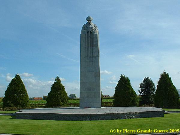
In de vette kleiakkers van het lichtglooiende landschap rond het Vlaamse dorpje St. Juliaan kan de argeloze reiziger mogelijk niets vermoeden van de gruwelijke taferelen die zich daar, 92 jaar geleden, hebben afgespeeld. Totdat die reiziger “Vancouver Corner” bereikt, een kruispunt van de N313, even ten noorden van de dorpskern, waar de metershoge “Canadian” in rouwhouding op zijn zwaard leunt. De “Canadian”, zoals de mensen uit de omgeving van Ieper zeggen, heet officieel “The Brooding Soldier”.
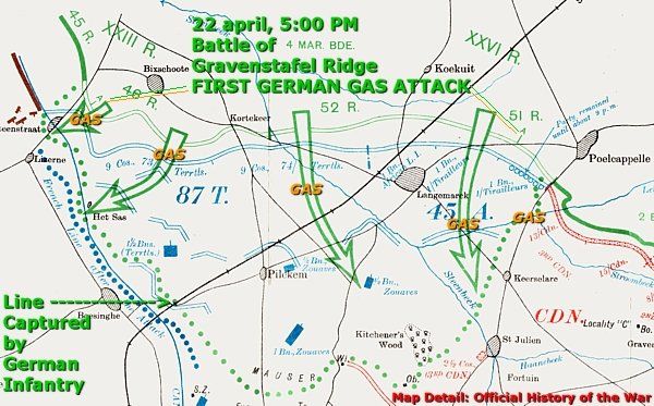
In 1915 woedde het tweede jaar van de Grote Oorlog van ’14-’18. Langs het Westelijk Front was rond Ieper een frontboog ontstaan, die van het noorden via het oosten terugliep naar het zuiden van Ieper. Aan de noordelijke kant van de frontboog, vanaf het Ieper-IJzerkanaal tot aan de weg van St. Juliaan naar Poelkapelle stonden Franse troepen in de loopgraven; links Franse infanteriesoldaten, rechts Zouaven uit de Franse kolonie Algerije. Aan hun rechterflank bewaakte de 1ste Canadese divisie de voorste linies. Tegenover hen stond in het noorden de Duitse, 52ste reservedivisie van het 4de Leger van Aartshertog Albrecht von Wűrttemberg opgesteld.
Na een artilleriebombardement gingen de Duitsers op 22 april 1915 in de aanval. Nabij de smalle Broenbeek openden de Duitsers in hun loopgraven om 5 uur ’s middags de kranen van hun bijna 30.000 gas-cylinders.
De uitvinder van het gas, de scheikundige, professor Fritz Haber
, was zelf ter plaatse aanwezig om te observeren, hoe zijn nieuwe uitvinding, chloorgas, in de praktijk werkte. Haber had de toepassing van het gas ontwikkeld in het laboratorium van het Kaiser Wilhelm Institut te Berlijn. Overigens was Haber van Joodse afkomst, maar hij had zich vanwege de carrière mogelijkheden bekeerd tot het christendom.
Chloorgas werkt agressief op de luchtwegen en ogen, en het gas veroorzaakt een snelle dood. Overigens was de toepassing van strijdgas al in 1907 verboden door artikel 23 van de Haagse Conventie, die Duitsland mede had ondertekend. De Duitschers hadden al geëxperimenteerd met het gas in oktober 1914 bij Neuve Chapelle en in januari 1915 bij Bolimow in het huidige Polen, maar zonder een bevredigend resultaat.
Rond 5 uur ’s middags stond die dag de wind voor de Duitsers eindelijk gunstig, een noordelijke wind. De gaswolk verspreidde zich vanaf het noorden zuidoostwaarts, in de richting van het dorp St. Juliaan. De Algerijnen kregen als eerst de volle laag van de gaswolk, die langer dan een uur boven het slagveld bleef hangen. Volgens ooggetuige, Sir Arthur Conan Doyle , grepen de Algerijnen naar hun keel om vervolgens op de grond, worstelend in een wanhopige doodstrijd tegen de verstikking, te sneuvelen. Gasmaskers waren toen nog onbekend. Wie zich nog redden kon, sloeg in paniek op de vlucht. Rond 7 uur ’s avonds waren alle Franse overlevenden op de vlucht geslagen, een gat van 8 kilometer in het front openlatend.
Rond 5 uur ’s middags stond die dag de wind voor de Duitsers eindelijk gunstig, een noordelijke wind. De gaswolk verspreidde zich vanaf het noorden zuidoostwaarts, in de richting van het dorp St. Juliaan. De Algerijnen kregen als eerst de volle laag van de gaswolk, die langer dan een uur boven het slagveld bleef hangen. Volgens ooggetuige, Sir Arthur Conan Doyle , grepen de Algerijnen naar hun keel om vervolgens op de grond, worstelend in een wanhopige doodstrijd tegen de verstikking, te sneuvelen. Gasmaskers waren toen nog onbekend. Wie zich nog redden kon, sloeg in paniek op de vlucht. Rond 7 uur ’s avonds waren alle Franse overlevenden op de vlucht geslagen, een gat van 8 kilometer in het front openlatend.
De Canadese 3de Brigade trok snel in dit stuk open front en stelde zich op bij Vancouver Corner om de Duitsers, die vanuit het noorden optrokken naar Pilkem Ridge, alsnog tegen te houden. Opvallend is dat de Canadezen ondanks de blootstelling aan gas wel stand wisten te houden. Soldaten die overeind bleven staan, en soldaten die niet op de vlucht sloegen, konden het gas beter weerstaan, dan soldaten die op de grond in de loopgraven lagen. Het gas zakte namelijk naar beneden, waar het langer bleef hangen. Ook werd er met enig succes geëxperimenteerd door in urine gedrenkte lappen stof voor de mond te houden. De Franse en de Canadese generaals besloten tot tegenaanvallen in die frontsector.
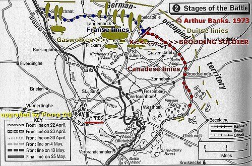
Op 24 april verspreidden de Duitsers even ten noorden van Vancouver Corner opnieuw chloorgas over de Canadese troepen. Tot 4 mei 1915 zouden er nog kleine veldslagen in de buurt plaatsvinden, bij ’s Graventafel, St. Juliaan, Frezenberg, en Bellewaarde.
Op 4 mei besloten de Britten hun front met 5 kilometer in te korten. De Duitschers namen definitief Pilkem Ridge in, en hielden de hoogte tot aan de Slag om Passendale (juli - november 1917). Aan het einde van de Tweede Slag om Ieper, op 25 mei 1915, telden de Fransen naar schatting 10.000 verliezen, de Britten verloren 59. 275 man, de Belgen verloren 1.530 man, en de Duitschers verloren 34.933 man. (*)
“The Brooding Soldier” kijkt peinzend in de richting van Langemark, waar vandaan het moordende gifgas kwam. Vancouver Corner is een historische plek, een kruispunt, waar ik altijd somber word over de toekomst.
Pierre
(*) Verliezen, afgeleid van de Engelse term “casualties”, een containerbegrip voor het totaal aan doden, vermisten, en gewonden tesamen.
Bron o.a.: Arthur Banks: “A Military Atlas of the First World War”, 1973.
(**) Voor meer foto’s bezoek mijn website-pagina’s over Langemark en St. Juliaan en klik hier
.


Inleiding: Franz Von Papen & Werner Horn; schaker en pion Onlangs stuitte ik in een oud boek (1) van 1919 op een opmerkelijk verhaal over een Duitse Luitenant, die in begin februari 1915 een half geslaagde bomaanslag pleegt op een spoorbrug over een grensrivier tussen de Verenigde Staten en Canada. Ook al staat de bekentenis van de dader, Werner Horn, deels in het boek te lezen, de naam van zijn opdrachtgever zal Horn blijven verzwijgen. Na wat verder zoeken vond ik ook de naam van Horn’s opdrachtgever, Franz von Papen, een van de aangeklaagden van het latere Neurenberg Proces in 1946. In een Grote Oorlog als de Eerste Wereldoorlog is Horn’s aanslag op de brug uiteraard slechts een bescheiden wapenfeit. Toch vermoed ik dat dit relatief onbekende verhaal, dat de geschiedenis is ingegaan als de “ Vanceboro International Bridge Bombing ”, nog interessante kanten kent. Het is onder andere een spionageverhaal over hoe in een groter plan een sluwe schaker zijn naïeve pion offert. Beknopte situatieschets Canada en de Verenigde Staten in 1915

This trip we start at the Léomont near Vitrimont and we will with some exceptions concentrate on the Battle of Lorraine of August-September 1914 in the area, called, the “Trouée de Charmes”, the Gap of Charmes. After the Léomont battlefield we continue our explorations to Friscati hill and its Nécropole Nationale. Next we pay a visit to the battlefield of la Tombe to go on to the Château de Lunéville. There we cross the Vezouze to move on southward to the Bayon Nécropole Nationale. At Bayon we cross the Moselle to pass Charmes for the panorama over the battlefield from the Haut du Mont. North-west of Charmes we will visit the British Military Cemetery containing 1918 war victims. From Charmes we go northward to the battlefield of the First French Victory of the Great War, the Battle of Rozelieures of 25 August 1914. North of Rozelieures we will visit the village of Gerbéviller. From there we make a jump northward to visit the ruins of Fort de Manonviller to finish with an interesting French Dressing Station bunker, west of Domjevin.

Though we depart from Badonviller in the Northern Vosges , we make a jump northward to the east of Lunéville and Manonviller . We start at Avricourt on the border of Alsace and Lorraine. From the Avricourt Deutscher Soldatenfriedhof we explore the southern Lorraine battlefields ; the mine craters of Leintrey , the Franco- German war cemetery and Côte 303 at Reillon , and some German bunkers near Gondrexon , Montreux , and Parux .

We depart from Raon-l’Etape to drive northward via Badonviller to Montreux to visit the " Circuit du Front Allemand 14-18", the Montreux German Front Walk 14-18, with its trenches , breastworks , and at least twenty bunkers.

North-east of Nancy, east of Pont-à-Mousson, and south-east of Metz we visit the battlefields of the Battle of Morhange of 14 until 20 August 1914. We follow mainly topographically the route of the French advance eastward over the Franco-German border of 1871-1918. During this visit, we try to focus on the day that the momentum of the battle switched from the French side to the advantage of the Bavarian side: the day of 20 August 1914, when the Bavarians rapidly re-conquered the territory around Morhange , being also the day of the start of their rather successful “Schlacht in Lothringen”. We will visit beautiful landscapes of the "Parc Naturel Régional de Lorraine", memorials, ossuaries, and cemeteries. Sometimes we will divert to other periods of the Great War, honouring Russian and Romanian soldiers, who died in this sector. We start our route at the border village of Manhoué, and via Frémery, Oron, Chicourt, Morhange, Riche, Conthil, Lidrezing, Dieuze, Vergaville, Bidestroff, Cutting, Bisping we will finish in Nomeny and Mailly-sur-Seille, where the Germans halted their advance on 20 August 1914, and where they constructed from 1915 some interesting bunkers.

South of Manhoué we start this trip at Lanfroicourt along the French side of the Franco-German 1871-1918 border, marked by the meandering Seille river. We visit some French bunkers in Lanfroicourt, near Array-et-Han and in Moivrons. From there we go northward to the outskirts of Nomeny and the hamlet of Brionne to visit the ( second ) memorial, commemorating the events in Nomeny of 20 August 1914. We continue westward to finish at the Monument du Grand Couronné at the Côte de Géneviève, a former French artillery base, which offers several panoramic views over the battlefield.

North of Pont-à-Mousson and south of Metz, we explore the relics of German bunkers and fortifications along the Franco-German 1871-1918 border. We start at Bouxières-sous-Froidmont to visit the nearby height of the Froidmont on the front line. This time we will show only a part of the Froidmont, focusing on its military significance. From the Froidmont we continue via Longeville-lès-Cheminot and Sillegny to the “Forêt Domaniale de Sillegny” to explore some artillery ammunition bunkers. Next we continue to Marieulles for its three interesting bunkers and to Vezon for its line of ammunition depot bunkers. From Vezon we continue to the “Deutscher Kriegsgräberstätte Fey – Buch”. From Fey we go eastward, passing 6 bunkers near Coin-lès-Cuvry to finish our trip at the top construction of the “Feste Wagner” or “Fort Verny”, north of Verny.

From Badonviller or the Col du Donon we continue north-eastward for a visit to an extraordinarily well restored sample of German fortifications: the Feste Kaiser Wilhelm II, or Fort de Mutzig, lying on a height, some 8 km. away from the 1871-1918 Franco-German Border.

We concentrate on the German side of the front around "Markirch", Sainte Marie-aux-Mines, the so-called "Leber" front sector . We first pay a visit to the Sainte-Marie-aux-Mines Deutscher Soldatenfriedhof, and next to the southern side of the Col de Ste. Marie for the many interesting bunkers of the German positions at the Bernhardstein, at the north-eastern slopes of the Tête du Violu. On the next photo page about the Haut de Faîte we will continue with a visit to the northern side of the pass and the "Leber" sector.